Islamabad - Capital City of Pakistan
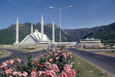
Location: Islamabad is located at the edge of the Pothohar Plateau at the foot of the Margalla Hills. Its elevation is 507 metres (1,663 ft). The modern capital and the ancient Gakhar city of Rawalpindi stand side by side and are commonly referred to as the Twin Cities. To the east of the city lies Murree and Kotli Sattian. To the north lies the Haripur District of Khyber Pakhtunkwah Province. Kahuta lies on the northeast, Taxila, Wah Cantt, and Attock District to the northwest, Gujar Khan, Kallar Syedian, Rawat, and Mandrah on the northeast, and Rawalpindi to the southwest. Islamabad is located 120 kilometres (75 mi) SSW of Muzaffarabad, 185 kilometres (115 mi) east of Peshawar, 295 kilometres (183 mi) NNE of Lahore, and 300 kilometres (190 mi) WSW of Srinagar, the capital of Indian Kashmir. Climate: Islamabad features an atypical version of a humid subtropical climate, with hot summers accompanied by a monsoon season followed by mild and wet winters. The hottest ...