Posts

Showing posts from June, 2010

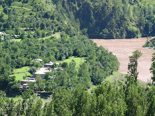
Leepa Valley - A Dream Land

Image
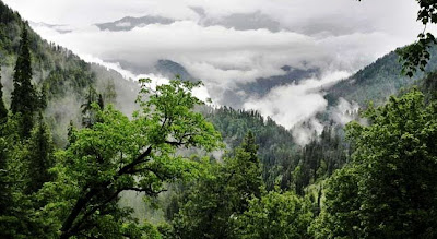
Location: Deep in the heart of the valley lies Leepa village at 1921m above sea level. This is the most fascinating & loveliest valley. A metalled road branches off for Leepa from Naily, 45 kms from Muzaffarabad, climbs over the Reshian Gali (3,200 m) and then descends to 1,677 m on the other side into the Leepa Valley. About 60 kilometers from Naily and 38 kilometers from Reshian, Leepa is a small village about at an altitude of 1921 meters. Its lush green rice fields in summer and typical wooden Kashmiri houses present a wonderful view to the people visiting the area. Walnut, Apple, Cherry and honey of Leepa are very popular. Climate: As autumn sets in the vale of Leepa, leaves fall off the trees, snowfall begins, the time is ripe to visit the vale for in winters the vale offers one of the most fascinating scenery in Azad Kashmir. Its lush green river fields in summer and typical wooden Kashmiri houses present a wonderful view. Walnut, apples, cherries and honey of Leepa are very

Muzaffarabad - Capital City of Azad Kashmir

Image
Location: Azad Jammu & Kashmir (AJK) extends from the plains of Punjab near Jhelum up through Mangla Lake to the foot hills of the Himalayas, and north to the mountains 6000-20000 feet above sea level. It is drained by three major rivers the Jhelum, the Neelum and the Poonch. The valleys are green and wooded. Muzaffarabad is the capital of Azad Kashmir, Pakistan, situated at the confluence of the Jhelum and Neelum rivers. This city  is located in Muzaffarabad District on the banks of the Jhelum and Neelum rivers. It is 138 kilometres from Rawalpindi and Islamabad and about 76 kilometres from Abbottabad. The Muzaffarabad  district is bounded by North-West Frontier Province in the west, by the Kupwara and Baramulla districts of on the Indian side of the Line of Control in the east, and the Neelum District of Azad Kashmir in the north. Description: Muzaffarabad city is one of the major cities in Pakistan. It is a hilly area and consists of wonderful cliffs. It is located in the Muzaf

Rawlakot - The Pearl Valley

Image
Location : Rawlakot is situated in the heart of district Poonch of Azad Jammu and Kashmir (AJK). The altitude of this beautiful Saucer�Shaped Valley is 1615 Meters. It is situated at a distance of 76 Kilometers from Kohala is also linked with Rawalpindi/Islamabad via Azad Pattan and Dhalkot and with Muzafarabad Kohala by black top roads. The construction of Guoien Nullah road between Rawlakot and Azad Pattan has considerably reduced the distance and journey time. It is a three-and-a-half-hour drive from Islamabad to Rawalakot, as the roads are narrow, mostly single-lane, and always under some type of construction. Surroundings: Surrounding villages include: Singola, Khaigala, Rairbun, Topa Soon (aka Soon Topa or just Topa), Kaimon, Thithrot, Motialmara, Trar Dewan, Chare, Chuck, Tranni, Dahmni, Parat, Pothi Bala/Makwalan, Kharek, Pakgali, Khayt Chrian, Mohri Furman Shah, Dreak, Banjosa, Hussainkot, Hurnamaira, Thorar, Rehara, Bangoin, Jandala, Timrota, Thala Tain and Pachiot. Bagh Dist